( කාලගුණ විද්යා දෙපාර්තමේන්තුව වෙබ් අඩවියෙන් උපුටා ගන්නා ලදි. )
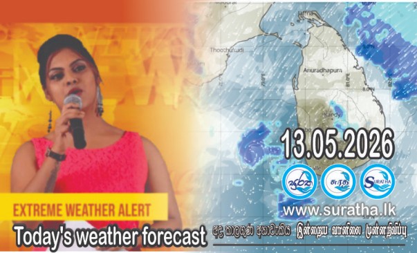
2026 මැයි මස 13 දින සඳහා කාලගුණ අනාවැකිය
2026 මැයි මස 13 දින උදෑසන 05.30 ට නිකුත්කරන ලදි.
ශ්රී ලංකාවට ඊසාන දෙසින් පිහිටා ඇති අඩු පීඩන කලාපය තවදුරටත් පවතී. මෙම පද්ධතිය ඉදිරි දින කිහිපය තුළ ආසන්නව උතුරු දෙසට ගමන් කිරීමට ඉඩ ඇත. මෙම පද්ධතියේ බලපෑම හේතුවෙන් දිවයිනේ දැනට පවතින වැසි සහිත තත්ත්වය ඉදිරි දින කිහිපය තුළත් පවතිනු ඇතැයි අපේක්ෂා කෙරේ.
බස්නාහිර, සබරගමුව, මධ්යම, වයඹ සහ උතුරු පළාත්වලත් අනුරාධපුර, ත්රිකුණාමලය, ගාල්ල සහ මාතර දිස්ත්රික්කවලත් විටින් විට වැසි හෝ ගිගුරුම් සහිත වැසි ඇති වේ.
දිවයිනේ අනෙකුත් ස්ථානවල පස්වරු 1.00 න් පසු වැසි හෝ ගිගුරුම් සහිත වැසි ඇති වේ.
බස්නාහිර, සබරගමුව, මධ්යම, වයඹ සහ ඌව පළාත්වලත් අම්පාර, මඩකලපුව, ගාල්ල, මාතර දිස්ත්රික්කවලත් ඇතැම් ස්ථානවලට මිලිමීටර් 100 ට වැඩි තද වැසි ඇති විය හැක.
ගිගුරුම් සහිත වැසි සමග ඇතිවිය හැකි තාවකාලික තද සුළං වලින් සහ අකුණු මඟින් සිදු වන අනතුරු අවම කර ගැනීමට අවශ්ය පියවර ගන්නා ලෙස ජනතාවගෙන් කාරුණිකව ඉල්ලා සිටිනු ලැබේ.
WEATHER FORECAST FOR 13 MAY 2026
Issued at 05.30 a.m. on 13 May 2026.
The low pressure area located northeast of the Sri Lanka, still persist. The system is likely to move nearly northwards during next few days. Due to the influence of this system, the current rainy conditions in the island are expected to continue for the next few days.
Showers or thundershowers will occur at times in Western, Sabaragamuwa, Central, North-western and Northern provinces and in Anuradhapura, Trincomalee, Galle and Matara districts.
Showers or thundershowers will occur at other places of the island after 1.00 pm.
Heavy falls above 100 mm are likely at some places in Western, Sabaragamuwa, Central, North-western, and Uva provinces and in Ampara, Batticaloa, Galle and Matara districts.
The general public is kindly requested to take adequate precautions to minimize damage caused by temporary localized strong winds and lightning during thundershowers.